
In QGIS kann man alle Layer des Geoportals des Bundes (map.geo.admin.ch) zu einem Projekt hinzufügen. Dieses Tutorial zeigt, wie 's geht.
Autor-Archive:Katia Soland
Schneller als die Postkutsche erlaubt?

Was heute Emails sind, waren im 18. Jahrhundert Briefe. Wir zeigen, wie sich die digitalisierten Briefe von und an Johann Caspar Lavater in einem GIS visualisieren lassen.
GIS Hub: Review in pictures

Looking back on 2.5 years of the GIS Hub.
Geoparsing: from place names in text to a map

In this brief blog post, we’ll explain what geoparsing is and how you can use the Python library developed by a former geography student at UZH.
DIY: Linking R with Web Mapping

If you missed yesterday’s workshop with Stefan from ESRI about the R-ArcGIS Bridge, we are happy to share the workshop material with you. You can read the theory part and do the exercises independently.
“Es gibt Wrack-Hotspots an Orten, wo ich sie nicht erwartet hätte”
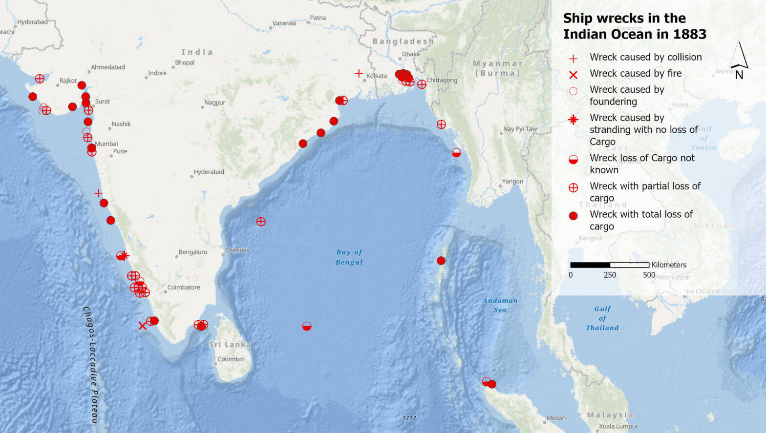
Was können uns Schiffswracks im 19. Jahrhundert im Indischen Ozean über das Klima der Vergangenheit sagen? Und was verraten uns die Aufzeichnungen dieser Wracks darüber, wie Klimawissen generiert wird? Diesen Fragen geht Debjani Bhattacharyya, Professorin für die Geschichte des Anthropozäns am Historischen Seminar der UZH, in ihrer Forschung nach.
Was sagen Volksmusik-Sendungen über uns aus?

Volksmusik-Sendungen sind mehr als nur Unterhaltung. Was sie über die Gesellschaft, Kultur und Heimat aussagen, dem geht ein SNF-Forschungsprojekt nach. Wir vom GIS Hub durften fürs Projekt eine Karte der Sendeorte erstellen.
Wie kann ich in QGIS ein Kartenlayout erstellen?

Du brauchst eine Karte für einen Artikel oder eine Präsentation? In diesem QGIS Tutorial zeigen wir dir, wie du eine Karte in ein Layout setzt, einen Titel, Nordpfeil und einen Massstab ergänzt und das Ganze dann als Bild oder PDF exportierst.
Wie vergleiche ich zwei Punktdatensätze? (III)

Wenn wir Punkte aus zwei Datensätzen pro Zelle zählen, können wir ihre Dichte vergleichen. Indem wir den Chi-Wert berechnen, können wir die aktuelle mit der erwarteten Dichte vergleichen.
Mit Punktdaten arbeiten (II)

In Teil II des Punktdatentutorials lernst du, wie du ein Gitternetz erstellen kannst. Du kannst die Punkte pro Gitterzelle zählen und Dichteoberflächen berechnen.