Find out how other people at UZH use a GIS software to improve their research. Read their story.
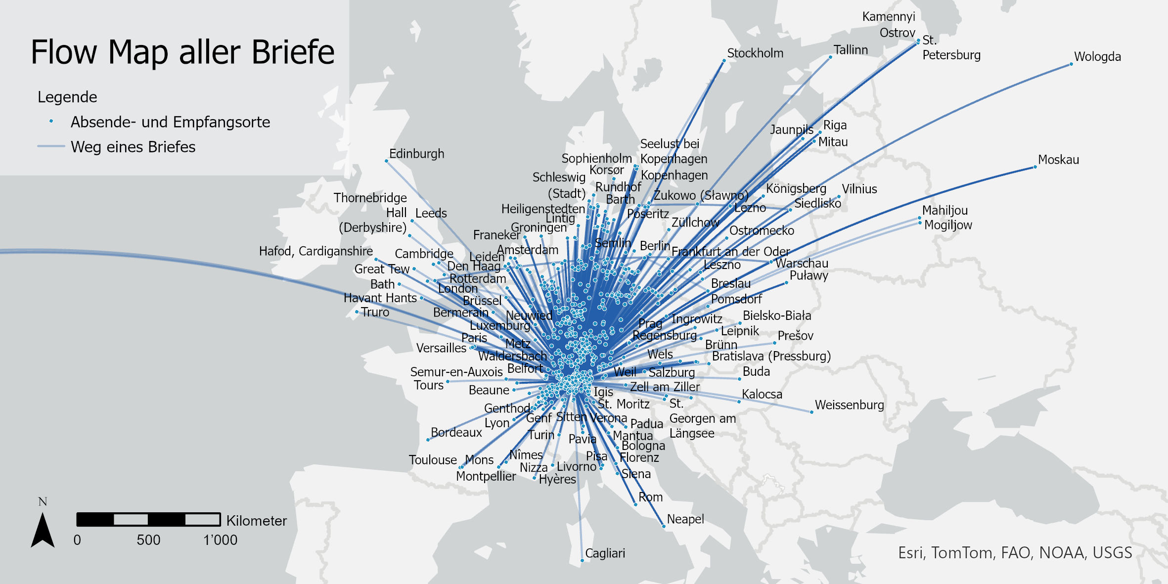
Was heute Emails sind, waren im 18. Jahrhundert Briefe. Wir zeigen, wie sich die digitalisierten Briefe von und an Johann Caspar Lavater in einem GIS visualisieren lassen.

Looking back on 2.5 years of the GIS Hub.

In this brief blog post, we’ll explain what geoparsing is and how you can use the Python library developed by a former geography student at UZH.
Continue Reading Geoparsing: from place names in text to a map
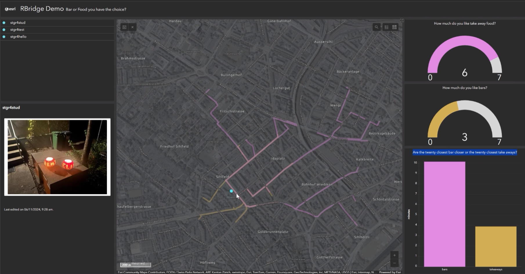
If you missed yesterday’s workshop with Stefan from ESRI about the R-ArcGIS Bridge, we are happy to share the workshop material with you. You can read the theory part and do the exercises independently.
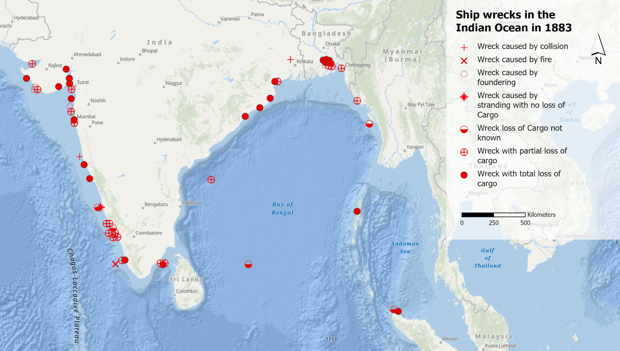
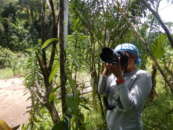
What can shipwrecks of the 19th century in the Indian Ocean tell us about the climate of the past? And what can the records of these wrecks tell us about climate knowledge production? Debjani Bhattacharyya, Professor for the History of the Anthropocene at UZH, explores these questions.
Continue Reading “There are hot spots of wrecks in places I did not expect”

Volksmusik-Sendungen sind mehr als nur Unterhaltung. Was sie über die Gesellschaft, Kultur und Heimat aussagen, dem geht ein SNF-Forschungsprojekt nach. Wir vom GIS Hub durften fürs Projekt eine Karte der Sendeorte erstellen.
Continue Reading Was sagen Volksmusik-Sendungen über uns aus?

How do companies, NGOs and public institutions monitor their progress towards the sustainable development goals (SDGs), and how can GIS software contribute? Five speakers provided answers from different perspectives at the event “Using GIS to tackle the SDGs”, organized by the GIS Hub and ESRI Switzerland.

As a dialectologist, Carlota de Benito Moreno is interested in how linguistic features change over time and space. By plotting her data on a map and combining it with historical data, she can detect diffusion patterns, divides, or clusters. Sometimes, she even discovers something she did not expect.

This summer, the Competence Centre for Geoinformation (CCG) of the Swiss Parks Network, in collaboration with the Department of Geography of the University of Zurich (GIUZ), organised an introductory training course on ArcGIS Pro for employees of the Swiss parks.
Continue Reading A new generation of desktop GIS for the Swiss Parks
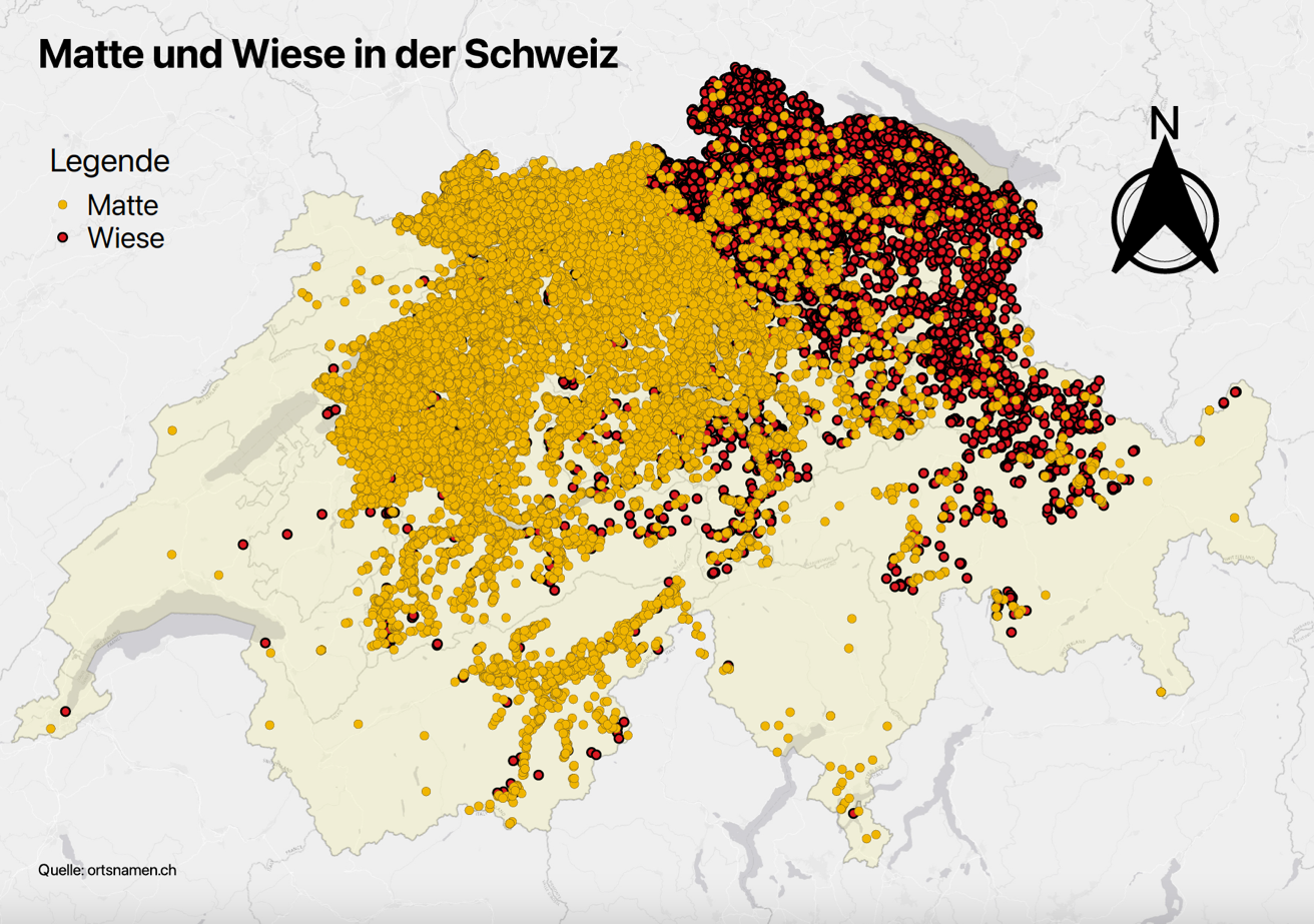
Wie sind Ortsnamen mit «Wiese» und mit «Matte» über die Schweiz verteilt? Wie lässt sich diese räumliche Verteilung erklären? Im Mastermodul «Einführung in die Onomastik» haben sich Germanistikstudierende unter anderem mit solchen Fragen befasst. Die Kartierung hat ihnen geholfen, Muster zu entdecken und Antworten zu finden.
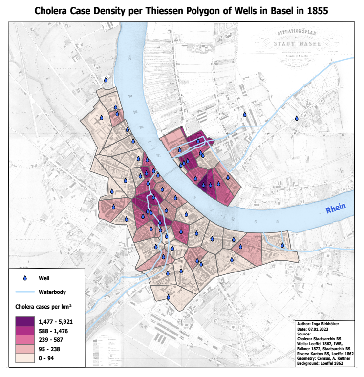
In 1854, Dr. John Snow creates a map of cholera cases in London’s Soho district. He can thus show that the disease is transmitted through contaminated water. In her Master’s thesis, Inga Birkhölzer investigated what can be extracted today from the cholera figures of 1855 in Basel using geographical visualisation.
Continue Reading Cholera 1855 in Basel: Between History, Epidemiology and Geographic Visualisation
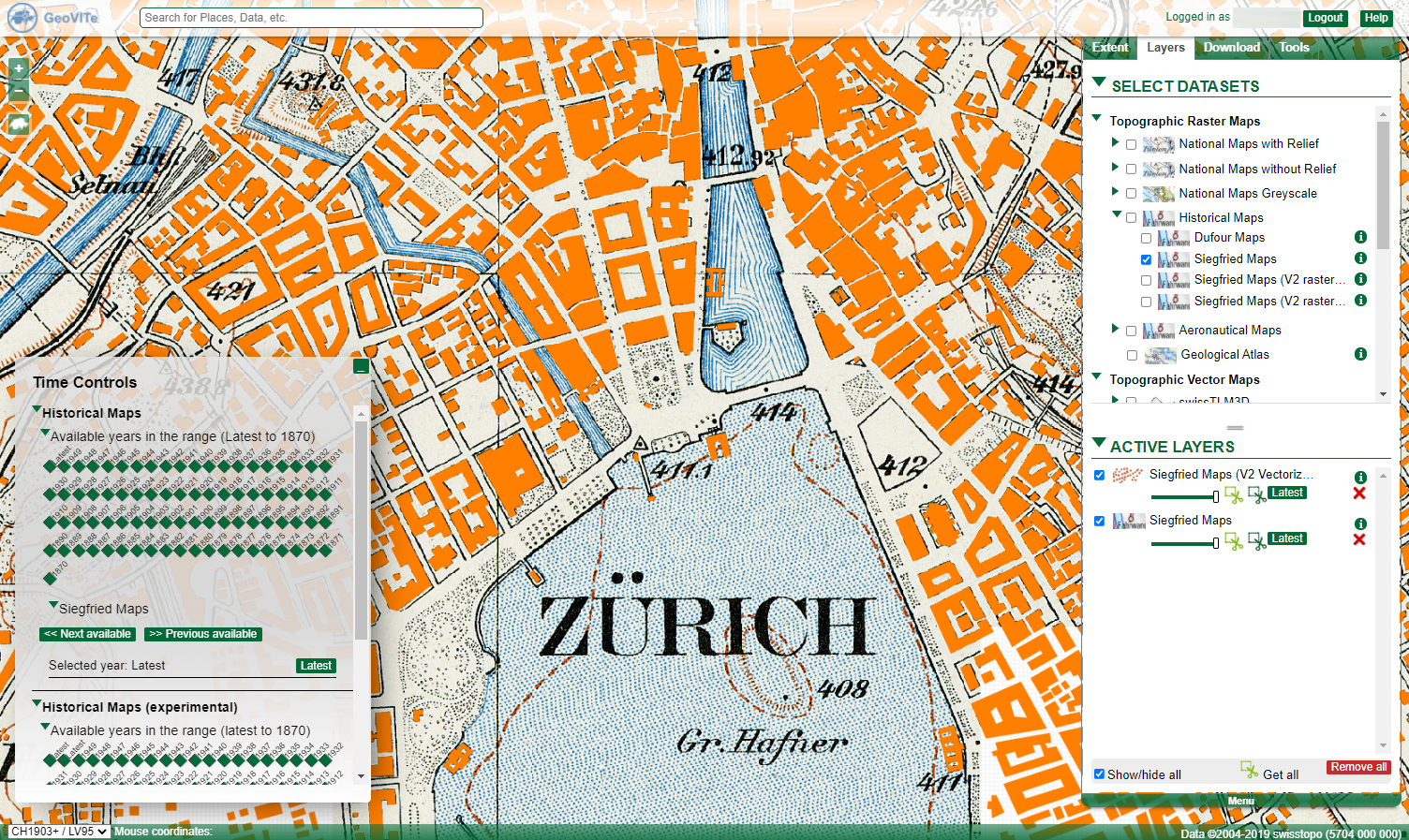
The GeoVITe platform provides topographic raster and vector maps, digital elevation models and orthophotos for research. Roman Walt, who supports and advises the users of the platform, explains in an interview how the data from GeoVITe can be used, what the added value is compared to the data from Swisstopo – and he reveals the funniest request.
Continue Reading From background maps and time series to toilet tiles in the national map look

ArcGIS Online is the little brother of ArcGIS Pro, a GIS software developed and maintained by ESRI. We collected seven reasons for you to try out the light version.

On Friday, the 11th of November, we officially launched the GIS Hub together with the participants of the workshop, members of the Advisory Board and the entire GIS Hub Team.
Eine Nation, eine Sprache – nach diesem Grundsatz wurde die Ausbreitung von Sprachen früher oft kartiert. «Doch Sprachen sind nicht nur territorial», sagt Johannes Kabatek, ordentlicher Professor für romanische Philologie an der Universität Zürich. Er sucht deshalb nach Möglichkeiten, wie sich Sprachen mehrschichtig im Raum und über die Zeit darstellen lassen.
Continue Reading Auf der Suche nach Mehrdimensionalität in Raum und Zeit

Als Niederlandist untersucht Chris De Wulf zum Beispiel, wie sich Diminutivendungen* in verschiedenen Dialekten über die Zeit verändern. Die Endungen extrahiert er aus Dokumenten wie Tagebüchern oder Urkunden – automatisch versteht sich – und speichert sie in Tabellen. Doch erst durchs Kartieren enthüllen sich ihm die Zusammenhänge.
Als sich Archäologe Timo Geitlinger vor ein paar Jahren zum ersten Mal an eine GIS-Software wagt, meint er, eine Wundermaschine vor sich zu haben. Heute hingegen weiss er, wie die Wunder zustande kommen und wie vielseitig und geschickt er die Software in seiner Forschung einsetzen kann.
Lovasoa Rakotozafy, a PhD student in Ecology at UZH, used a GIS software to prepare her field work in Madagascar. «There are a lot of things of which I don’t know how I would have done them without the software», she admits.
Continue Reading “I will use GIS software again in my career”